Continuous. Connected. Safe.
And joyful.
This is what the Santa Clara Valley Transportation Authority aims to achieve with its Central Bikeway project, a roughly 10-mile bicycle superhighway through San Jose and Santa Clara that would be the first of its kind in the Bay Area.
“It will set a lot of precedents for hopefully future corridors,” said VTA land use planner Brent Pearse during a presentation of the project. “We will be using joy as an evaluation metric.”
The Central Bikeway was recently proposed as part of the Santa Clara Countywide Bike Plan in 2018, a comprehensive look at helping cyclists travel more easily and safely between cities by VTA staff.
Santa Clara County already has 800 miles of bikeways, including dedicated bike lanes on roads such as San Fernando Street in downtown San Jose. There are 200 miles of dedicated bike trails, but many popular routes—such as the Guadalupe River Trail and Coyote Creek Trail—are not connected through a continuous, uninterrupted path.
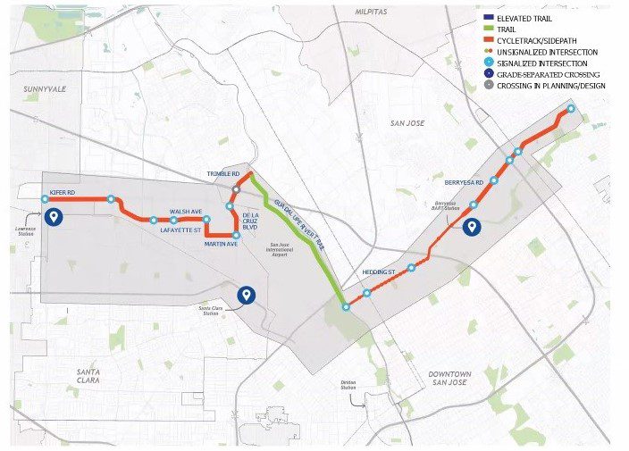
The transportation agency is studying three alternatives for the proposed bicycle superhighway, nicknamed the Walsh Wizard, the Trail Trackway and the Shortliner. All routes extend east of Highway 680 in San Jose.
Members of VTA’s Bicycle and Pedestrian Advisory Committee discussed the three alternatives last week during their monthly meeting. Only one San Jose resident, Brandon Alvarado, serves on the 16-member committee.

Pearse said the Walsh Wizard—which would run just north of Lawrence Caltrain Station in Santa Clara along Berryessa Road in San Jose—is projected to be the slowest of the routes between cities because of its length, with 22% of the bikeway along the Guadalupe River Trail. This path would also require the least roadway changes and would likely be the cheapest.
Committee member Tim Oey said this route leaves cyclists vulnerable to the river’s seasonal rise, which floods over the bike path.
The Trail Trackway—the most “trail-like” of the options—follows the Penitencia Creek Trail, Coyote Creek Trail, Caltrans Corridor and Caltrain Corridor to San Tomas Aquino Creek Trail finally ending on Central Expressway. Grade separations, or elevated paths, would need to be built on at least two points, making it a more arduous ride for casual cyclists.

Committee member Betsy Megas said the proposed trails bikeway could present a safety issue, particularly for female cyclists.
“That is a personal safety thing to my mind,” Megas said. “That sounds like it has the strong potential to be both isolated and have relatively little access.”
Oey agreed, adding that while trails are fun, they don’t serve commuters well.
“When I think of a bike superhighway, I want to get to where I want to get to quicker,” Oey said.
The shortest-length option is the Shortliner, which would extend from East El Camino Real to Mabury Road and Capitol Avenue in San Jose. Pearse said this route would benefit commuters who want relatively quick access to restaurants and retail along the storied El Camino.

Committee member John Cordes said that while the Shortliner may be shortest in length, it likely would not be the shortest in terms of time, given the heavy traffic along El Camino. Pearse said VTA could coordinate traffic signals to ensure cyclists would not need to stop at every intersection along the busy street.
The VTA planner said residents are more likely to use the route to commute to and from work; however, the agency’s initial public outreach showed that residents also hope to use the bikeway for leisure and exercise.
“The hard thing about planning facilities like this, over long distances, is those tradeoffs present themselves really quickly,” Pearse said.
VTA will hold two public meetings on the Central Bikeway project tomorrow and Wednesday. Readers can learn more about the project and how to access the meetings at vta.org/centralbikeway.
Contact Sonya Herrera at [email protected] or follow @SMHsoftware on Twitter.


Leave a Reply
You must be logged in to post a comment.