

Santa Clara County is planning the region’s first bike superhighway—but a route still needs to be selected.
“I don’t see a bicycle superhighway going down El Camino,” Erik Lindskog, a member of VTA’s Bicycle and Pedestrian Advisory Committee, said at Wednesday’s meeting. “I think a bicycle superhighway needs to be a little more separate from traffic.”
The idea of a superhighway stems from VTA’s Santa Clara Countywide Bike Plan released in 2018. The plan proposes a central bikeway to help cyclists travel more easily and safely between cities.
Santa Clara County already has 800 miles of bikeways, including dedicated bike lanes on roads such as San Fernando Street in downtown San Jose. There are 200 miles of dedicated bike trails, but many popular routes—such as the Guadalupe River Trail and Coyote Creek Trail—are not connected through a continuous, uninterrupted path.
VTA allocated $903,000 in funding toward the project, and aims to complete an analysis of the preferred route by January.
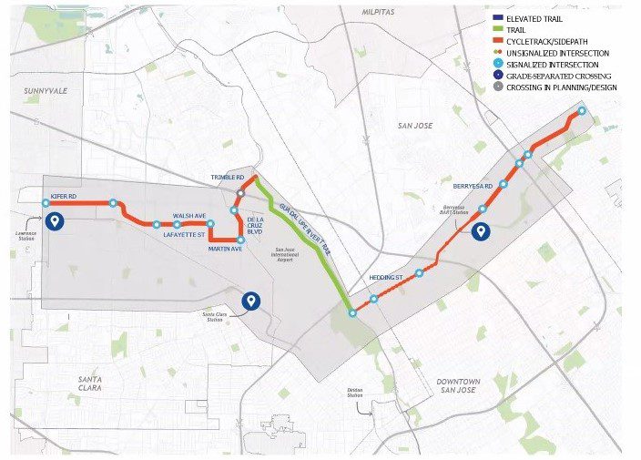
The transit agency reached out to local bicyclists to evaluate three alternative routes for a protected bike path stretching from East San Jose to Santa Clara. The three routes—dubbed the Shortliner, Trail Trackway and Walsh Wizard—take different paths from east of Highway 680 north of Mabury Road to Santa Clara as far west as Lawrence Expressway.
VTA judged each route by eight metrics: equity, compatibility, desirability, sustainability, access, joy, safety and feasibility. Equity measures how attractive a route is to new users, women and people of color, while desirability is based on whether segments of a route lead to popular destinations.
The Shortliner route scored highest among the most categories and follows an on-street path from Mabury Road, Taylor Street, Hedding Street and The Alameda to El Camino Real. The route is the shortest of the three alternatives.

San Jose resident and cyclist Andy Murillo said that when they travel via bike, they choose routes with as few turns as possible, which makes the Shortliner route attractive. However, they cautioned that riding along The Alameda and El Camino Real can be dangerous.
“The optimal option would be to make it easier and safer to bicycle The Alameda (and) along El Camino Real, rather than along a bike route that you have to piece together,” Murillo told San José Spotlight. “For a lot of people, it’s a lot easier to imagine yourself sharing a trail with pedestrians than sharing a street with cars.”
The Trail Trackway route scored highest for equity and safety. The route extends along the Penitencia Creek Trail, Coyote Creek Trail, Caltrans Corridor, Caltrain Corridor and San Tomas Aquino Creek Trail through Central Expressway.
However, VTA considers the route infeasible along some stretches of San Jose and Santa Clara. For example, in Santa Clara the route faces gaps in the Caltrain Corridor which are expensive to connect.

The third route is the Walsh Wizard, which tracks along Berryessa Road, Hedding Street, the Guadalupe River Trail and Trimble Road, eventually reaching Kifer Road.
Lindskog is disappointed that the Trail Trackway route is considered infeasible, and said it may be a better alternative than the on-street options, given that many of the streets on the route are planned to have bike lanes added anyway.
Betsy Megas, who also serves on the bike and pedestrian committee, said the Trail Trackway route is an attractive option, but that on-street segments are necessary to provide a safe alternative during nighttime or in periods of flooding.
Many streets in San Jose are designated as bike routes, but don’t have basic features such as bike lanes that make roads safer for cyclists, Murillo said.
“I’m kind of salty that The Alameda is designated as a bike route, but there are no bike lanes,” Murillo said. “I’ve actually stopped riding on The Alameda for the most part because of having to share travel lanes with cars.”
VTA plans to survey more residents next month, and may set up a booth at San Jose street fair Viva Calle in September to solicit more feedback on the three alternatives. Readers can learn more about the bikeway alternatives at VTA’s website.
Contact Sonya Herrera at [email protected] or follow @SMHsoftware on Twitter.
Leave a Reply
You must be logged in to post a comment.