

In a surprising upset, the state commission charged with redrawing California’s political boundaries drew San Jose into four districts after briefly considering an option that would have limited it to three.
The California Citizens Redistricting Commission voted Monday night to approve a map that places San Jose in four congressional districts: 16, 17, 18 and 19.
Mayor Sam Liccardo celebrated when the commission advanced a map that would have allowed San Jose to retain a city-majority congressional district. When it became clear the commission was considering a four-way split again, Liccardo made impassioned pleas on social media for residents to testify against the map.
He didn’t immediately respond to a request for comment.
The commission adopted the four-way split for San Jose in part to avoid a district that sprawled from San Mateo to San Luis Obispo counties.
“I think that was the first point in which we started to evaluate what the impacts of a three-split within the city of San Jose would do to the general area,” Commissioner Isra Ahmad told San José Spotlight. “The commission fell back to the four-split in San Jose with the mind of trying to make as many communities of interest as whole as possible.”
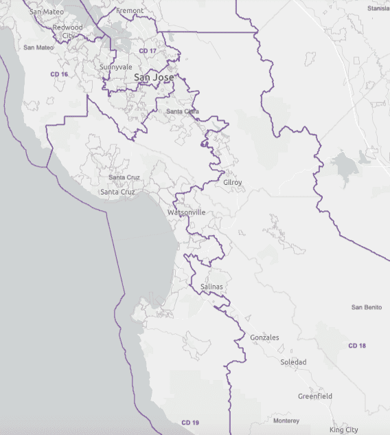
The new congressional lines makes some other changes in Santa Clara County. Santa Clara, Cupertino, Sunnyvale and Milpitas are now in District 17. Mountain View, Palo Alto and Los Gatos are in District 16. Evergreen and Edenvale are in District 19, which stretches to Santa Cruz and all the way down the coast to Paso Robles. A chunk of Alum Rock is in District 18, which sweeps south to include Morgan Hill, Gilroy, Watsonville and King City.
Terry Christensen, a retired San Jose State University political science professor and host of Valley Politics, is somewhat optimistic about the new boundaries.
“Best spin we can put on this is that San Jose could have not one but (four) representatives if candidates get their act together,” he said.
The state commission must follow six criteria for redrawing congressional boundaries: maintain equal populations in districts; comply with the federal Voting Rights Act; ensure contiguous borders; minimize the division of cities, counties and neighborhood communities of interest; ensure districts are geographically compact; and ensure each Senate district has two complete and adjacent Assembly districts. The commission does not consider how maps will affect incumbents or candidates.
Ahmad noted San Jose, like much of the South Bay, is densely populated, which makes it challenging to create districts that don’t divide communities of interest.
She added the split was also necessary to preserve a Latino-majority district to comply with the Voting Rights Act. This district includes a portion of San Jose in the Alum Rock area that contains Latino essential workers.
The commission will vote on Dec. 26 to certify the map and will then present it and a final report to the Secretary of State on Dec. 27.
Contact Eli Wolfe at [email protected] or @EliWolfe4 on Twitter.
Leave a Reply
You must be logged in to post a comment.