

|
Getting your Trinity Audio player ready...
|
Creating what is essentially a brand new neighborhood from scratch is no easy feat — a fact the Palo Alto City Council wrestled with Monday during a discussion of the San Antonio Road Area Plan, a roadmap for building more than 1,500 homes.
The plan hopes to bring thousands of new homes, as well as retail, office and park space to the southern edge of the city where it borders Mountain View. The area around San Antonio Road has historically been dominated by low-density commercial and industrial businesses, but the city hopes to make great strides in housing development there to meet lofty state-mandated goals.
Previous discussions have toyed with the idea of adding approximately 1,500 homes to the area per the city’s housing element, which serves as a master plan to guide new housing development to meet state quotas. But city staff on Monday presented the council with an even higher number: as many as 7,400 homes if Palo Alto chooses to maximize height and density capacity across the board.
That new number caused much of the council, and the public, to balk. But Councilmember George Lu emphasized the upper threshold should be treated as more of a reference point and could not realistically be met in the near future.
Planning Director Jonathan Lait also clarified staff wanted to present city leaders with a full range of options for development, but conceded the department could have done a better job at communicating the numbers.
“We are trying to create a sense of place in the San Antonio area,” Lait said. “Getting those higher quality elements of what connects and makes a neighborhood a neighborhood requires a certain amount of density, it requires a certain amount of office so that we can translate these ideas into something that brings it together cohesively.”
Staff sought council feedback on general themes of the development proposal for San Antonio, with the expectation that a more robust discussion will take place in June, when the council will be tasked with narrowing the list of options related to height limits, density, retail and transportation modes.
The early feedback on Monday focused largely on the first two in that list.
The San Antonio Road Area Plan splits the 275 acres into several sub-areas based on the likelihood of redevelopment, taking into account any recent development as well as ownership and institutional uses.
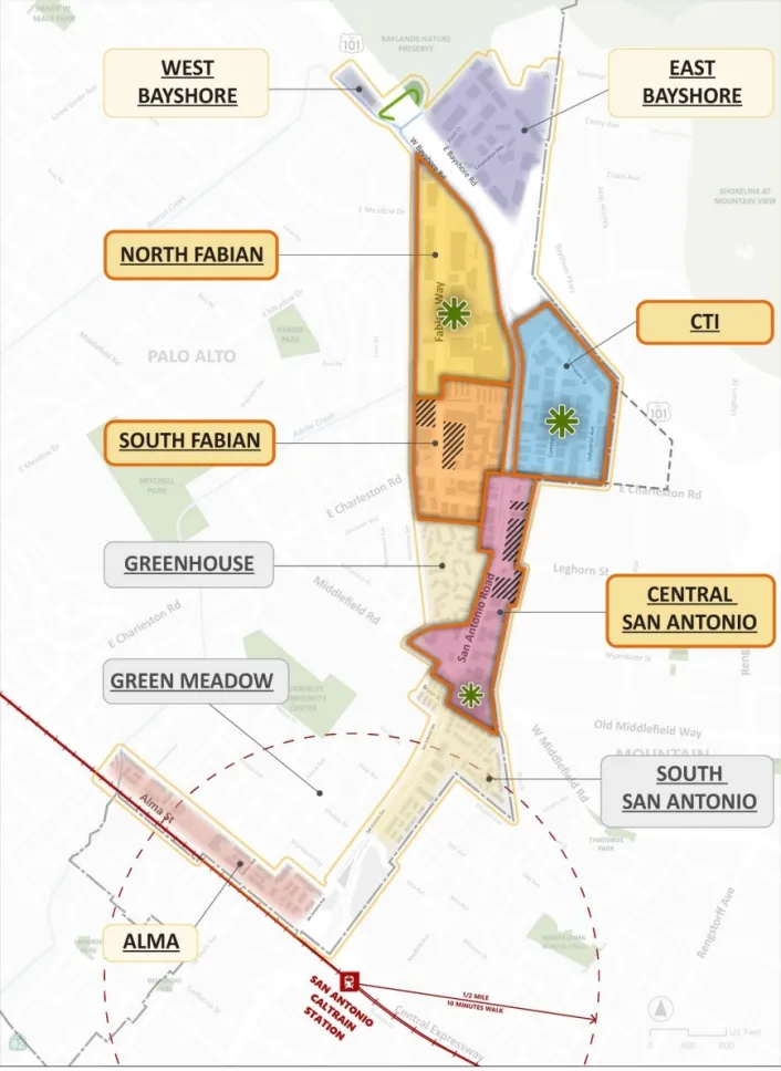
The sub-areas designated as priority for their high development potential include the area along San Antonio Road between East Charleston Road and Byron Street (excluding the Greenhouse I and II condominium developments), north and south portions of Fabian Way and the area containing Commercial Street, Transport Street and Industrial Avenue, referred to as the CTI sub-area in planning documents.
Leave a Reply
You must be logged in to post a comment.